Whiteout on the ridge. Phone dead at mile 40. Trail vanished in the fog.
Your survival hinges on one non-negotiable truth: When nature steals visibility and kills batteries, ordinary gear fails.
So what can you do? The answer is invest in a personal GPS tracker that offers emergency features to make your next outdoor adventure safer. In this article, we will discuss hiking GPS trackers and:
- Triple-satellite stealth tech that never loses you—canyons, blizzards, or rainforests.
- One-press SOS protocols that bypass dead zones to summon rescue teams.
- Solar-powered defiance that outlives storms, freezing temps, and human endurance.
- Terrain traps exposed before you step—offline maps screaming “cliff ahead!”
Stop gambling with false confidence.
Start surviving.
Key Features of Hiking GPS Trackers
So what features are best when it comes to outdoor safety? We spoke with the experts at SpaceHawk GPS and they said very clearly that not all personal GPS devices are built the same. Therefore, making the wrong choice and finding yourself in a emergency situation can literally be life-altering decision. Here are some of the key features they said you should look for before buying a personal GPS tracking device on Amazon.
Multi-Network Satellite Positioning
Devices cross-reference signals from GPS (U.S.), Galileo (E.U.), and GLONASS (Russia) simultaneously, accessing 30+ satellites to maintain location accuracy in signal-challenged terrain. This triple-network redundancy prevents positioning failures in deep canyons, dense forests, or mountainous regions where single-network systems lose lock.
Satellite SOS with Two-Way Communication
A dedicated physical button initiates emergency signaling via Iridium or Globalstar satellite constellations, bypassing cellular networks entirely. Coordinates transmit instantly to 24/7 response centers like GEOS, while integrated keyboards enable text-based situation reporting and rescue coordination—functioning at any global latitude.
Adaptive Power Management
Solar-harvesting panels recharge batteries during daylight exposure, while configurable power modes extend operation from days to months. Users adjust tracking intervals (e.g., 2-minute to 4-hour updates), disable non-essential sensors, or activate ultra-low-power states to preserve functionality during extended emergencies.
Offline Topographic Intelligence
Preloaded digital elevation models display terrain contours, hydrological features, and infrastructure without cellular connectivity. Geofencing protocols trigger visual/auditory alerts when approaching user-defined hazard zones (e.g., avalanche paths, property boundaries, or elevation thresholds), overlaying real-time positioning on 3D terrain maps.
One-Touch Emergency Signaling
Physically segregated panic SOS buttons—reinforced for impact resistance—transmit distress signals without menu navigation. A single press dispatches coordinates to monitoring services, while secondary strobes activate for visual tracking. This failsafe operates with cracked screens, frozen interfaces, or compromised user capacity.
5 Best Hiking GPS Trackers for Personal Safety
Garmin GPSMAP 67i
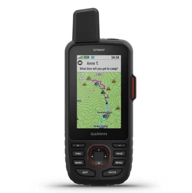
The GPSMAP 67i excels in expeditions where communication and battery longevity are non-negotiable. Its rugged, IPX7-rated body houses a vivid 3-inch display readable in direct sunlight. The device leverages Garmin’s inReach satellite network for SOS alerts and text messaging, while multi-band GNSS ensures accuracy even under heavy tree cover. Real-time tracking allows contacts to monitor your progress via a shared web link.
Key Features:
- 180-hour standard battery life (840 hours in expedition mode)
- Global SOS and two-way messaging via Iridium
- Preloaded TopoActive maps and BirdsEye Satellite imagery
- Multi-band GNSS support (GPS, Galileo, GLONASS)
How It Works: Users trigger SOS via a dedicated button, connecting to GEOS 24/7 emergency coordination. Daily check-ins use preset messages to conserve power. The “TracBack” feature reverses routes to retrace steps if disoriented.
User Feedback: *”Used SOS during a climbing partner’s injury in the Wind River Range—rescue teams pinpointed us within 20 minutes. Battery lasted a 10-day trek with 30% left”. The device also received positive online comments in a reddit forum.
Garmin inReach Mini 2
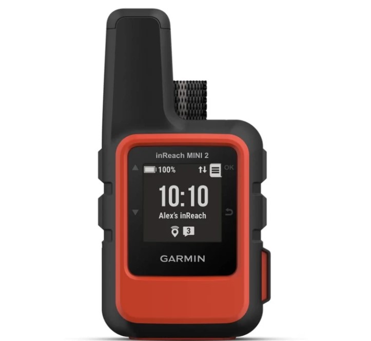
Weighing just 3.5 oz, this ultracompact communicator prioritizes emergency connectivity over detailed mapping. The personal GPS tracker pairs with smartphones via Bluetooth for easier messaging and map viewing but operates independently as a GPS. Critical for solo adventurers, its satellite SOS function works globally, and customizable tracking intervals extend battery life to 14 days.
Key Features:
- 14-day battery life (10-minute tracking intervals)
- Iridium-based SOS and text messaging
- Bluetooth smartphone pairing for route syncing
- IPX7 waterproof rating
How It Works: Pressing the SOS button sends location data to GEOS, while the “Track Progress” feature shares real-time coordinates with designated contacts. The device stores basic waypoints for breadcrumb navigation.
User Feedback: “Attached to my pack strap on the PCT—sent ‘delayed’ messages prevented panic when storms slowed me down. Screen is tiny but adequate for coordinates”. “Subscription cost is worth the peace of mind”
Garmin eTrex Solar
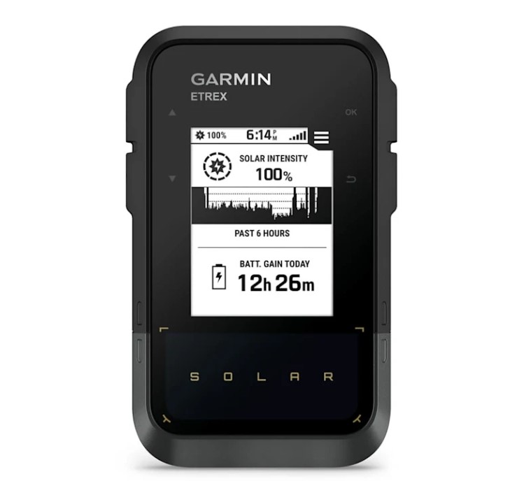
Ideal for thru-hikers avoiding recharge stops, the eTrex Solar combines affordability with near-unlimited power. The hiking GPS offers solar panel extends battery life indefinitely in sunny conditions, while the monochrome display reduces energy consumption. Though lacking satellite messaging, it provides reliable GPS/GLONASS tracking and supports route importing via Bluetooth.
Key Features:
- Unlimited battery potential with solar charging
- Multi-GNSS support (GPS, GLONASS, Galileo)
- Preloaded worldwide basemap with shaded relief
- IPX7 weather resistance
How It Works: Solar cells recharge during daylight hiking, with battery life extending to 200+ hours. Routes planned in apps like Gaia GPS sync wirelessly, and the “Track Manager” logs elevation gain/loss.
User Feedback: “Completed the Colorado Trail without charging. Sun kept it alive even on cloudy days”. “No-frills navigation—perfect for staying found without distractions”
Garmin Montana 700i
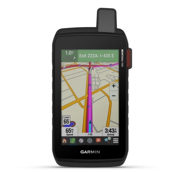
With a 5-inch touchscreen, the Montana 700i simplifies navigation for complex off-trail routes. Preloaded TOPO maps show terrain details clearly, while its built-in camera geotags photos for route documentation. Satellite messaging and MIL-STD-810 durability make it suitable for harsh environments like alpine or desert treks.
Key Features:
- 5-inch glove-friendly touchscreen
- 18-hour battery (330 hours in expedition mode)
- 8MP geotagging camera and 16GB storage
- Global SOS and two-way messaging
How It Works: The “Active Weather” feature delivers forecasts via satellite subscription, and the “GroupTrack” function monitors up to 20 devices—ideal for guiding parties.
User Feedback: “Led a group through the Grand Canyon’s remote routes—screen size prevented wrong turns in slot canyons. Heavy but worth the weight”.”Camera quality beats phone pics in dust storms”.
DeLorme inReach Explorer+
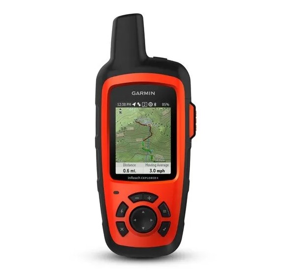
Now part of Garmin’s lineup, this legacy model remains favored for its straightforward satellite communication. The personal GPS tracker includes basic topographic mapping and supports Earthmate app integration for detailed map viewing on smartphones. Yes, that is one of The 100-hour tracking battery suits weeklong backpacking trips.
Key Features:
- 100-hour battery (10-minute tracking)
- Iridium-based SOS and global messaging
- Preloaded DeLorme TOPO maps
- IPX7 waterproof rating
How It Works: Messages are sent via the Earthmate GPS tracking app or device keypad, with location points embedded. The “Location Sharing” page updates every 10 minutes for followers.
User Feedback: “Messaged rangers about a wildfire near the Sierras—rerouted our group safely. Interface feels dated but never failed”. “Battery outlasted my Garmin Fenix watch by 3 days
The Bottom Line
These features transform a GPS from a “nice-to-have” to a critical layer of safety. They address the real nightmares:
- “I can’t see where I am” → Multi-network GNSS locks your location in hellish terrain.
- “No one knows I’m hurt” → Satellite SOS screams for help where phones go silent.
- “My device died” → Solar/power modes ensure it lives longer than you can.
- “I walked into danger” → Topo maps + geofencing shout warnings before you step off the edge.
- “I’m too injured to call” → The SOS button needs one press.
Remember: Tech fails if you don’t practice. Test SOS functions before your trip. Charge it. Know how to read the map. Your tracker isn’t magic—it’s a tool that turns panic into protocol when things go south.